The Melnupe (literally 'Blackriver') is not one of Latvia's better-known rivers, but it may be my favorite.
Rising near Alūksne, it's more of a rivulet than a river for much of its course, but does eventually broaden into something that just about deserves to be called a river. It meanders for 73 kilometers (though the distance from end to end as the stork flies is just 35 km) in a picturesque manner before discharging into the even more picturesque Mustjõgi (which rather confusingly means 'Blackriver' in Estonian), which in turn eventually discharges into the poster-child of Latvian-Estonian water courses, the Gauja/Koiva river.
So it might be said that the waters of the Melnupe go from Latvia to Estonia on a sort of fluvial day trip and then come back again – very appropriate for this series of stories.
The name 'Blackriver' has something Faulkneresque about it. It's nice to imagine that the banks of the Melnupe are inhabited by ancient, degenerating families with dark secrets that quite often resolve themselves in tragic drownings. Drowning is, after all, one of the most popular ways to die in this part of the world, and if you must drown it is probably better to do it in an atmospherically-named river than a septic tank or a vat of kvass.
This reminds me of a joke an Estonian friend once told me: Why do so many Estonians drown each year? Because it is embarrassing to ask for help.
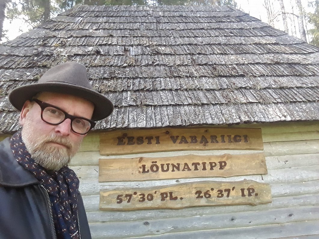
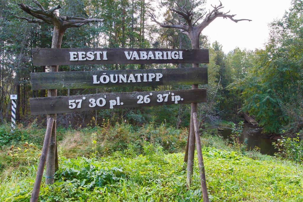
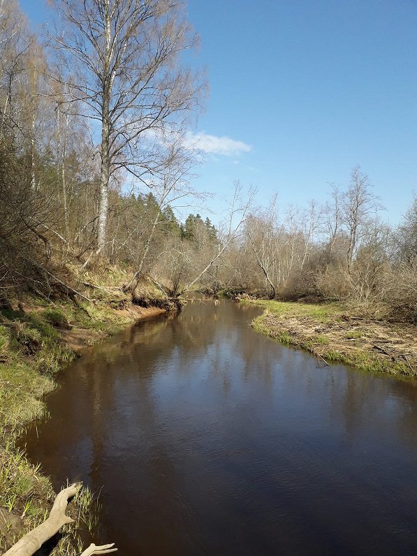
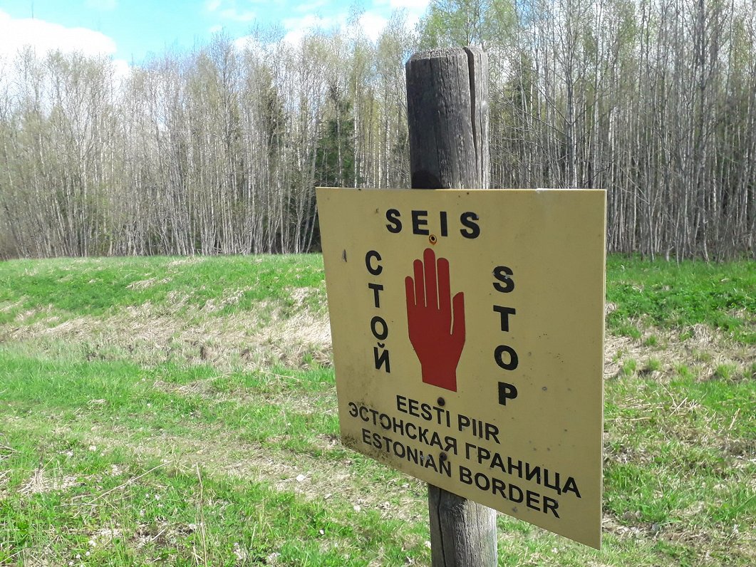
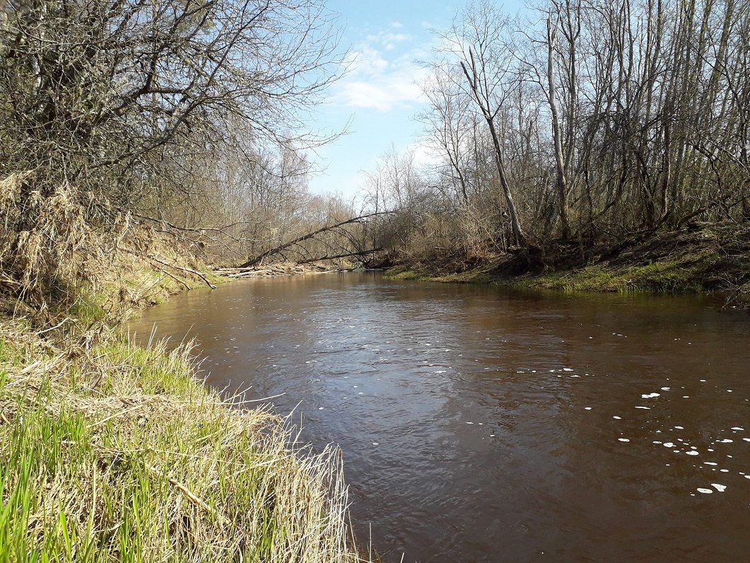
There is one short stretch of the Melnupe that is particularly appealing. On its way north, it crosses the main Rīga-Pskov highway not far from the town of Ape. Yes, the names in this part of the world are odd to English speakers. About five hundred meters later it touches the southernmost point in Estonia and for about two kilometers thereafter, the Melnupe forms the border between Latvia and Estonia. If you're standing on the other bank, it's the Peetri jõgi (Peter river), which is a rather dull name, rendered even duller by the fact that I associate the word 'Peetri' with a very bland chain of Estonian pizza restaurants.
So what do we find at the southernmost point of Estonia? Well, over on the Latvian side, nothing much. There is the Melnupe logging trail which ends nearby, and a couple of private summer houses along the riverbank, but they are discreetly tucked away from view.
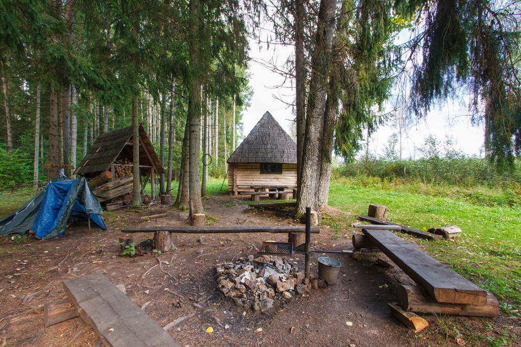
On the Estonian side though, there's something quite nice: a log cabin operated by RMK, the Estonian state forestry company which contains a small natural history exhibit. In addition there is a woodshed (complete with firewood and tools), some benches, a toilet, a campfire cooking spot, a sign giving the latitide and longitude and a nature trail. You can even stay the night in the hut if you are so inclined.
Because of the lay of the land, the arrangement of private property and the larger-than-it-looks nature of the river, it's theoretically possible but practically inadvisable to get to the southernmost point in Estonia from the Latvian side of the river. Unless you have experience constructing military pontoon bridges or own an amphibious landing vehicle – which might be misunderstood – you are almost certainly better off taking the fairly lengthy detour via Ape to reach the southernmost point in Estonia from one of the innumerable points north. Then you have a couple of options: to walk down from the farmstead at the start of the official nature trail or to walk down along a field's edge from the 'Greenway' hiking trail which runs all the way to Ape and passes an abandoned old border post.
The nature trail is the pleasanter option, but being persistent and liking the idea of an unusual one-man border incursion, I took a few detours from the trail and made some interesting discoveries. The first of these is, I dare to say, of major national and geographical significance.
It is a popular boast among our northern neighbors that while Estonia has hundreds of islands of all shapes and sizes, we Latvians have precisely none. Well, with the greatest respect, I question this propaganda, because along this section of the Melnupe there are several sharp meanders and tucked among the twisting waters are some sandbanks on what might be described as the Estonian side of the river. One of these little islands is notable for the fact that the marker delineating the Latvian national border is on the 'Estonian' side of the river i.e. the island must be in Latvia.
Clearly over the years the river has changed course, easily pushing its sandy banks this way and that, while the border has of course remained in the same internationally agreed position. The net result is the creation of an island belonging to Latvia in very much the same way that the volcanoes of Iceland occasionally spit out a new promontory for the land of fire and ice. So Latvia has an island after all! The fact that it isn't in the sea and will almost certainly disappear again when the river decides to swing back the other way is neither here nor there – very much like the border itself.
The second discovery I made off piste from the nature trail was a beaver dam and lodge completely straddling the Melnupe/Peetri jõgi. Therefore it is an international lodge half in Latvia and half in Estonia. One can only imagine the rackets in alcohol, coffee and diesel the duty-dodging aquatic rodents within have sunk their elongated teeth into. It must be like the Medellin Cartel in there, only furrier.
The third discovery I made along the banks of the Peetri jõgi was a substantial pile of what I am pretty sure was fresh bear scat. It certainly wasn't beaver droppings. As might be imagined, this sent me back to the marked trail at express speed and curtailed further exploration.
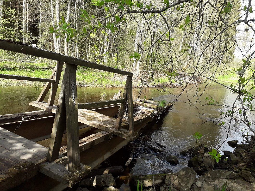
Yes, latitude: 57.509518 longitude: 26.616666, is a pleasant place. There is what looks like the remains of an old footbridge, so once it must have been easy to walk across the river. But somehow this spot is now a bit out of the way. What is needed is something to really put it back on the international map even for people who are not drawn to grid references for their own sake.
As Tartu is acting as a European capital of culture next year, and is stressing that it also involves a large chunk of southern Estonia – including this southernmost point – I think a special effort should be made.

I suggest that as a warm-up for his concert in Tartu on June 10, Estonia and Latvia jointly extend an invitation to the British musician Sting to cross the Melnupe from Latvia to Estonia via the beaver dam on June 9 and play an acoustic concert at the southernmost point of Estonia. He could even put a message in a bottle and send it down the river. We'll be able to fish it out when it floats back into Latvia so as not to further pollute the Baltic Sea.
Catering could be provided courtesy of Peetri Pizza and, while there is certainly a chance the musical superstar might be eaten by a bear during his concert, disapponting thousands of fans in Tartu 24 hours later and causing a major international embarassment, I think it's a risk worth taking.